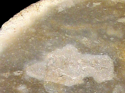
Foto: Jehanne Féblot-Augustins, 2005.
| Material name: | CN4c |
| Synonyms: | Silex Crétacé supérieur Nord - Sénonien (Campanien) |
| Material (geologic): | Late Cretaceous (Campanian, Senonian) flint |

Foto: Jehanne Féblot-Augustins, 2005. |
| Mode of occurrence: | Small irregular nodules, or flat cobbles. |
| Cortex: | Worn and smooth, or alluvial neo-cortex (cobbles), 1 to 5 mm thick, transition sharp. |
| Colour: | Greyish brown to light brownish grey (2.5Y 5/2 to 6/2). |
| Pattern: | Featureless, otherwise either randomly flecked with white specks or faintly mottled; a few large patches of unreplaced matrix. |
| Appearance: | Poor homogeneity (pores), lustre dull to medium, opaque, moderately smooth, medium-grained. |
| Structure: | No particular structure, apart from one sample which displays convoluted bioturbation figures and a fluidal arrangement of grains in some areas. |
| Texture: | Wackestone. |
| Matrix: | Opaque to semi-opaque. |
| Grains: | 20 to 25 %, pale, rounded with high to low sphericity, or irregularly shaped, often agglomerated and surrounded by recrystallization haloes; rather poorly sorted (100 to 500 µ, mean size 250 µ). |
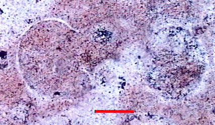
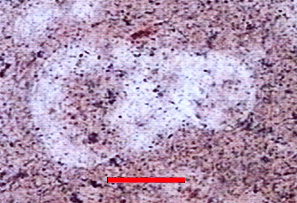
| Grain composition: | Bryozoan fragments, globose planktonic foraminifera (Hedbergella ? with a marginal keel), variable amount of fine-walled monaxon spicules. |
 Globotruncanidae (Hedbergella ?) in a CN4c flint type. Highly silicified. |
 Globotruncanidae (Hedbergella ?) in a CN4c flint type. Highly silicified. |
|
|
Photos: A. Arnaud Vanneau, (Laboratoire de Géodynamique des Chaînes Alpines, Grenoble) Determination: M. Caron, Université de Fribourg. |
| Further information: | Click here for the original French description (opens in a new window), or here for more information on the attributes used in the description (use your browser's "BACK"-button to return here). |
| Citing: | Information on citing this page can be found here. |
| Locality: | Neuville-sur-Ain / St-André, France, Ain department |
| Synonyms: | Sampling site Bugey 47 after Féblot-Augustins |
| Geographical description: | The material was collected near a slight rise within a large bend of the river "le Suran", just to the NW of St. André, some five kilometres west of Poncin. |
| Geographical co-ordinates: |
east/x 832,5 north/y 2124,8 (Lambert zone II, NTF)
This corresponds roughly with |
| Co-ordinate precision: |
The coordinates given were taken from a large-scale map, and are within approx. 50 metres of the actual spot. The latitude/longitude coordinates are a direct transformation of these data on WGS84 and are accurate to the same level, so don't be deceived by the apparently high precision to the second. The location can be found on the 1:25 000 topographical map sheet 3129 E of the French Institut Géographique National. |
| Geology: |
According to the geological map, the substrate belongs to unit RQ (P1), which consists of residual fluviatile deposits (attributed to the Late Pliocene) with quartzite — and more seldom flint — cobbles. Map of all sampled localities of Late Cretaceous flint in the Bugey (PDF, 54 KB, opens in new window). |
| Type of source: | Secondary. |
| Other types of flint: | Apart from the CN4c-flint described here, also several other flint-types of Senonian age can be found here: CN2a, CN2c, CN3a, and CN3b, as well as Early Cretaceous Ht3 silex. |
thumb.jpg) Foto: Jehanne Féblot-Augustins, 2005 |
| Locality: | Leyssard / Solomiat - Meillarenche, France, Ain department |
| Synonyms: | Sampling site Bugey 57 after Féblot-Augustins |
| Geographical description: | The sample was collected along the small road which connects Solomiat with the main D 979 road, some 350 metres to the southwest of the village. |
| Geographical co-ordinates: |
east/x 842.37 north/y 2134 (Lambert zone II, NTF)
This corresponds with |
| Co-ordinate precision: |
The Lambert reference given was taken from a large-scale map, and are within approx. 50 metres of the actual spot. The latitude/longitude coordinates are a direct transformation of these data on WGS84 and are accurate to the same level, so don't be deceived by the apparently high precision to the second. The location can be found on the 1:25 000 topographical map sheet 3229 W of the French Institut Géographique National. |
| Geology: |
According to the geological map, the substrate belongs to unit Rs, which represents clays-with-flints, in this case presumably the residual of unit C6 (Late Cretaceous, Senonian) limestones. Map of all sampled localities of Late Cretaceous flint in the Bugey (PDF, 54 KB, opens in new window). |
| Type of source: | Secondary. |
| Other types of flint: | Besides the CN4c material, flints of the CN2b and CN5 type (both of similar age) might be found here. |
thumb.jpg) Foto: Jehanne Féblot-Augustins, 2005 |
| Locality: | Leyssard / Solomiat - le Mortaret, France, Ain department |
| Synonyms: | Sampling site Bugey 58 after Féblot-Augustins |
| Geographical description: | The sample was collected on some fields directly to the southwest of Solomiat, a very small village/hamlet just off the main D 979 road, approx. 10 kilometres west-northwest from Nantua as the crow flies. |
| Geographical co-ordinates: |
east/x 842,6 north/y 2135,6 (Lambert zone II, NTF)
This is equivalent to |
| Co-ordinate precision: |
The coordinates given were taken from a large-scale map, and will be accurate to a level of approx. 50 metres. The latitude/longitude coordinates are a direct transformation of these data on WGS84 and are accurate to the same level, the high presicion to the arc-second is given to prevent the introduction of addition inaccuracy. The location can be found on the 1:25 000 topographical map sheet 3229 W of the French Institut Géographique National. |
| Geology: |
According to the geological map, the substrate consists of clays-with-flint (unit Rs), resulting from the decalcification of Late Cretaceous formations. Map of all sampled localities of Late Cretaceous flint in the Bugey (PDF, 54 KB, opens in new window). |
| Type of source: | Secondary. |
| Other types of flint: | Besides the CN4c-type, the CN4a variety can be found here too. |
thumb.jpg) Foto: Jehanne Féblot-Augustins, 2005 |
| Locality: | Leyssard / Solomiat - Le Petit Bois, France, Ain department |
| Synonyms: | Sampling site Bugey 59 after Féblot-Augustins |
| Geographical description: | The source is located just east of the small road which connects the hamlet of Solomiat with the D 979, the main road in the northern part of the Bugey, linking Bourg-en-Bresse with Bellegarde-sur-Valserine. Solomiat lies approx. 10 kilometres as the crow flies WNW of Nantua, on a terrace on left bank of the river Ain, some 360 metres above the bottom of the narrow valley. |
| Geographical co-ordinates: |
east/x 842.7 north/y 2135.3 (Lambert zone II, NTF)
This corresponds with |
| Co-ordinate precision: |
As usual with the sites from the Bugey, the French Lambert-values were taken off a large-scale topographical map and the geographical coordinates were calculated directly by transforming those values on WGS84. The precision of both are within approx. 50 metres. The location can be found on the 1:25 000 topographical map sheet 3229 W of the French Institut Géographique National. |
| Geology: |
The flint is to be found in residual loams left after the decalcification of Late Cretaceous (Senonian) limestones, unit Rs on the geological map. Map of all sampled localities of Late Cretaceous flint in the Bugey (PDF, 54 KB, opens in new window). |
| Type of source: | Secondary. |
| Other types of flint: | Apart from the CN4c-type, also two other flints of Senonian age can be found here, namely CN1a and CN2b. |
thumb.jpg) Foto: Jehanne Féblot-Augustins, 2005 |
| Locality: | Poncin / La Bierle, France, Ain department |
| Synonyms: | Sampling site Bugey 62 after Féblot-Augustins |
| Geographical description: | The material was collected on a south-facing slope overlooking the eastern "outskirts" of Poncin, 20 kilometres SE of Bourg-en-Bresse. |
| Geographical co-ordinates: |
east/x 838,3 – 838,6 north/y 2125,3 – 2125,5 (Lambert zone II, NTF)
This corresponds with |
| Co-ordinate precision: |
With a surface of several hectare, the site is quite extended, so no bother about the precision of the coordinates The latitude/longitude coordinates point somewhere to the centre of the area, so don't bother about the single seconds (in this area, 1 second of latitude is ca. 30 metres on the ground, a longitudinal second approx. 20 metres) The location can be found on the 1:25 000 topographical map sheet 3229 W of the French Institut Géographique National. |
| Geology: |
The site is located on fluvio-glacial deposits from the Würm I and II stages (units agl a-b on the geological map), in contact with Aquitanian sediments (Early Miocene, unit ml). This results in a mix of Upper Cretaceous an Cenozoic flints being present at this site. The CN4a type can be dated to the Campanian. Map of all sampled localities of Late Cretaceous flint in the Bugey (PDF, 54 KB, opens in new window). |
| Type of source: | Secondary. |
| Other types of flint: | As so often on secondary sites, quite a lot of other types of flint can be found here, mostly of Late Cretaceous age: CN2b, CN4a, CN4b, as well as the Cenozoic "silex lacustre" of the T1 type. |
thumb.jpg) Foto: Jehanne Féblot-Augustins, 2005 |
| Locality: | Poncin / Breignes - Pierre-Feu 1, France, Ain department |
| Synonyms: | Sampling site Bugey 70 after Féblot-Augustins |
| Geographical description: | The sample was collected along a path between the hamlets of Cheneval and Breignes, a hunderd metres to the west of sampling site 34, Poncin / Breignes - Pierre-Feu 2, and 700 metres east of the "le Chanay" farm. |
| Geographical co-ordinates: |
east/x 838.1 north/y 2122.9 (Lambert zone II, NTF)
This corresponds roughly with |
| Co-ordinate precision: |
The coordinates are to the nearest 50 metres on a detailed topographical map. The Lat/Long are a direct transformation of these on WGS84, within the same limits of accuracy. The location can be found on the 1:25 000 topographical map sheet 3230 W of the French Institut Géographique National. |
| Geology: |
According to the geological map, the substrate belongs to unit m2bC-Rs : Late continental Miocene (Tortonian) and possibly clays-with-flint of Late Cretaceous origin. Map of all sampled localities of Late Cretaceous flint in the Bugey (PDF, 54 KB, opens in new window). |
| Type of source: | Secondary. |
| Other types of flint: | The Late Cretaceous CN1a and CN2a flints occur here too. |
thumb.jpg) Foto: Jehanne Féblot-Augustins, 2005 |
| Last modified on: November 25, 2005 |
Contents primarily by: Jehanne Féblot-Augustins |
Comments to: |