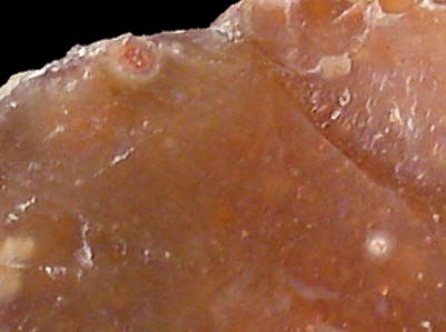
Foto: Jehanne Féblot-Augustins, 2005.
- La Bierle
Sampled sites:
| Material name: | T1 |
| Synonyms: | "silex lacustre" |
| Material (geologic): | Cenozoic (Tertiary) flint |

Foto: Jehanne Féblot-Augustins, 2005. |
Sampled sites:
|
| Mode of occurrence: | Small globular nodules. |
| Cortex: | White, chalky and very rough, 1 to 5 mm thick, superficially stained brown by the enclosing clay, transition sharp but irregular. |
| Colour: | Weak reddish brown (2.5YR 4/3). |
| Pattern: | Flecked with white specks. |
| Appearance: | very homogeneous material with a shiny lustre, translucent in thin flakes, smooth, fine-grained. |
| Structure: | micro-vugs lined with quartz crystals below the cortex. |
| Texture: | Wackestone. |
| Matrix: | Translucent. |
| Grains: | 25 %, white or stained red by iron oxides, occasionally surrounded by recrystallisation haloes, subangular with high sphericity, poorly sorted (220 to 700 µ). |
| Grain composition: | Chara (charophytes) oogons against a background of very small grains (40 µ); iron oxides. |
| Further information: | Click here for the original French description (opens in a new window), or here for more information on the attributes used in the description (use your browser's "BACK"-button to return here). |
| Citing: | Information on citing this page can be found here. |
| Locality: | Poncin / La Bierle, France, Ain department |
| Synonyms: | Sampling site Bugey 62 after Féblot-Augustins |
| Geographical description: | The material was collected on a south-facing slope overlooking the eastern "outskirts" of Poncin, 20 kilometres SE of Bourg-en-Bresse. |
| Geographical co-ordinates: |
east/x 838,3 – 838,6 north/y 2125,3 – 2125,5 (Lambert zone II, NTF)
This corresponds roughly with |
| Co-ordinate precision: |
With a surface of several hectare, the site is quite extended, so no bother about the precision of the coordinates The latitude/longitude coordinates point somewhere to the centre of the area, so don't bother about the single seconds (in this area, 1 second of latitude is ca. 30 metres on the ground, a longitudinal second approx. 20 metres) The location can be found on the 1:25 000 topographical map sheet 3229 W of the French Institut Géographique National. |
| Geology: |
The site is located on fluvio-glacial deposits from the Würm I and II stages (units agl a-b on the geological map), in contact with Aquitanian sediments (Early Miocene, unit ml). The exact age of the flints is not known, but certainly Cenozoic. Map of all sampled localities of Cenozoic flint in the Bugey (PDF, 40 KB, opens in new window). |
| Type of source: | Secondary. |
| Other types of flint: | As so often on secondary sites, quite a lot of other types of flint can be found here, mostly of Late Cretaceous age: CN2b, CN4a, CN4b, CN4c. |
thumb.jpg) Foto: Jehanne Féblot-Augustins, 2005 |
thumb.jpg) Foto: Jehanne Féblot-Augustins, 2005 |
| Last modified on: November 15, 2005 |
Contents primarily by: Jehanne Féblot-Augustins |
Comments to: |