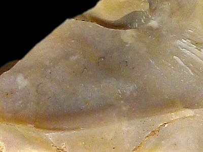
Foto: Jehanne Féblot-Augustins, 2005.
- St-André (Neuville-sur-Ain)
- Chatanay
- Bassement
| Material name: | CN2c |
| Synonyms: | Silex Crétacé supérieur Nord - Sénonien (Campanien) |
| Material (geologic): | Campanian (Senonian, Late Cretaceous) flint |

Foto: Jehanne Féblot-Augustins, 2005. |
Sampled sites:
|
| Mode of occurrence: | ´Small nodules, or highly rolled pebbles and cobbles. |
| Cortex: | Worn, smooth and thin (1 mm), occasionally with a shiny lustre; smooth alluvial neo-cortex on pebbles and cobbles; transition always sharp. |
| Colour: | Olive grey hues (5Y 4.5/2, 5Y 5/1.5) to light brownish grey (2.5Y 6.5/2). |
| Pattern: | Featureless. |
| Appearance: | Homogeneous material with a medium lustre, semi-opaque to subtranslucent in thin flakes, smooth and fine-grained. |
| Structure: | No particular structure. |
| Texture: | Mudstone. |
| Matrix: | Semi-opaque. |
| Grains: | 5 to 7.5 %, very small pale rounded elements (40-80 µ), skeletal grains with high sphericity (max. 400 µ). |
| Grain composition: | Numerous globose planktonic foraminifera (e.g. Hedbergella planispira), rare small biserial foraminifera (Heterohelicidae), discrete chambers of 200-250 µ; sponge spicules are rare or absent. |
| Further information: | Click here for the original French description (opens in a new window), or here for more information on the attributes used in the description (use your browser's "BACK"-button to return here). |
| Citing: | Information on citing this page can be found here. |
| Locality: | Neuville-sur-Ain / St-André, France, Ain department |
| Synonyms: | Sampling site Bugey 47 after Féblot-Augustins |
| Geographical description: | The material was collected near a slight rise within a large bend of the river "le Suran", just to the NW of St-André, some five kilometres west of Poncin. |
| Geographical co-ordinates: |
east/x 832,5 north/y 2124,8 (Lambert zone II, NTF)
This corresponds roughly with |
| Co-ordinate precision: |
The coordinates given were taken from a large-scale map, and are within approx. 50 metres of the actual spot. The latitude/longitude coordinates are a direct transformation of these data on WGS84 and are accurate to the same level, so don't be deceived by the apparently high precision to the second. The location can be found on the 1:25 000 topographical map sheet 3129 E of the French Institut Géographique National. |
| Geology: |
According to the geological map, the substrate belongs to unit RQ (P1), which consists of residual fluviatile deposits (attributed to the Late Pliocene) with quartzite — and more seldom flint — cobbles. Map of all sampled localities of Late Cretaceous flint in the Bugey (PDF, 54 KB, opens in new window). |
| Type of source: | Secondary. |
| Other types of flint: | Apart from the CN2c-flint described here, also several other flint-types of Senonian age can be found here: CN2a, CN3a, CN3b, and CN4c, as well as Early Cretaceous Ht3 silex. |
thumb.jpg) Foto: Jehanne Féblot-Augustins, 2005 |
| Locality: | Poncin / Chenavel - Chatanay, France, Ain department |
| Synonyms: | Sampling site Bugey 48 after Féblot-Augustins |
| Geographical description: | The sampling-site is located directly adjacent to a narrow road, a bit over a kilometre to the (S)SW of Poncin. |
| Geographical co-ordinates: |
east/x 836,7 to 836,8 north/y 2124 to 2124,2 (Lambert zone II, NTF)
This corresponds roughly with |
| Co-ordinate precision: |
As the site is a few hectares in size, precision is not of the highest importance, but the coordinates lie well within the area. The geographical coordinates point to a spot near the centre of the site. The location can be found on the 1:25 000 topographical map sheet 3230 W of the French Institut Géographique National. |
| Geology: |
The material from this site can be classified as surface-collected flint or in eroded gulleys, Chenavel sector, clays-with-flint of various geological origins (Early and Late Cretaceous); Unit S (Rs). Map of all sampled localities of Late Cretaceous flint in the Bugey (PDF, 54 KB, opens in new window). |
| Type of source: | Secondary. |
| Other types of flint: | Besides the Campanian CN2c material, several types of Late Cretaceous material can be found here (CN1a, CN2a, CN4a, CN4b, and CN6), as well as Early Cretaceous Ht3 flint. |
thumb.jpg) Foto: Jehanne Féblot-Augustins, 2005 |
| Locality: | Neuville-sur-Ain / St-André - Bassement, France, Ain department |
| Synonyms: | Sampling site Bugey 61 after Féblot-Augustins |
| Geographical description: | The sampling site lies in a small wooded valley half a kilometre to the south of the hamlet of Confranchette d'en Bas, which can be reached by following a narrow road for about a kilometre towards the southwest from St-Martin-du-Mont. |
| Geographical co-ordinates: |
east/x 832.3 north/y 2125.7 (Lambert zone II, NTF)
This corresponds roughly with |
| Co-ordinate precision: |
The location was documented on a large-scale topographical map, from which the French coordinates were taken. The latitude/longitude coordinates are a direct transformation of these data on WGS84 and rounded to the nearest arc-second. The location can be found on the 1:25 000 topographical map sheet 3129 E of the French Institut Géographique National. |
| Geology: |
The flint lies reworked in glacial deposits of Würmian age, unit "a" on the local geological map. Map of all sampled localities of Late Cretaceous flint in the Bugey (PDF, 54 KB, opens in new window). |
| Type of source: | Secondary. |
| Other types of flint: | Besides the CN2c-type, also the CN2a variety as well as CN3b flint can be found here. All flints originate in Late Cretaceous limestones, but were transported during the last Ice Age to their current position. |
thumb.jpg) Foto: Jehanne Féblot-Augustins, 2005 |
| Last modified on: November 25, 2005 |
Contents primarily by: Jehanne Féblot-Augustins |
Comments to: |