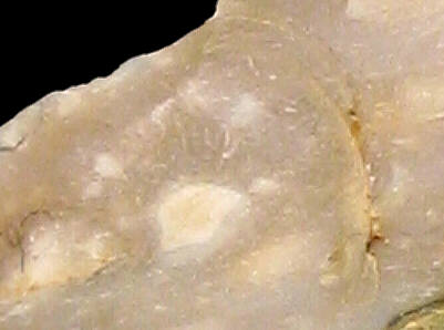
Foto: Jehanne Féblot-Augustins, 2005.
- Villes-En Lachat
- Ochiaz-Champ Bottu
Sampled sites:
| Material name: | CE2 |
| Synonyms: | Silex Crétacé supérieur Est - Sénonien (Campanien) |
| Material (geologic): | Redeposited Late Cretaceous (Campanian) flint from Miocene sediments. |

Foto: Jehanne Féblot-Augustins, 2005. |
Sampled sites:
|
| Mode of occurrence: | Ovoid pebbles and cobbles (En Lachat), rare fragments of tabular flint (Champ Bottu). |
| Cortex: | Rolled neo-cortex, smooth and thin (<1 mm), grey (En Lachat); thin pitted neo-cortex, stained dark brown-grey (Champ Bottu); transition always sharp. |
| Colour: | Light brownish grey (2.5Y 6/2 to 5/2) with dark grey patches (N4) at En Lachat, yellowish brown to brownish yellow (10YR 5.5/6) at Champ Bottu. |
| Pattern: | Spotted (grain aggregates surrounded by recrystallization haloes). |
| Appearance: | Homogeneous material with a medium lustre, subtranslucent, smooth, fine-grained. |
| Structure: | Some samples display a fluidal arrangement of grains. |
| Texture: | Wackestone. |
| Matrix: | Subtranslucent. |
| Grains: | 20 to 25 %, very small pale rounded elements (50-80 µ), occasionally agglomerated, skeletal grains with high sphericity contained between 125 and 300 µ. |
| Grain composition: | Fragments of thin-walled sponge spicules, small globose planktonic foraminifera, rare small biserial foraminifera (Heterohelicidae), several discrete punctated spheres of 250 µ. |
| Further information: | Click here for the original French description (opens in a new window), or here for more information on the attributes used in the description (use your browser's "BACK"-button to return here). |
| Citing: | Information on citing this page can be found here. |
| Locality: | Villes / En Lachat, France, Ain department |
| Synonyms: | Sampling site Bugey 49 after Féblot-Augustins |
| Geographical description: | The source is located in some fields, under a kilometre away in a northwesterly direction from the hamlet/village of Villes, some eight kilometres SW of Bellegarde-sur-Valserine. |
| Geographical co-ordinates: |
east/x 866,3 north/y 2127,5 (Lambert zone II, NTF)
This corresponds roughly with |
| Co-ordinate precision: |
The coordinates given were taken from a large-scale map, and are within approx. 50 metres of the actual spot. The latitude/longitude coordinates are a direct transformation of these data on WGS84 and are accurate to the same level; the 1-second precision is given to prevent any rounding-errors. The location can be found on the 1:25 000 topographical map sheet 3329 W of the French Institut Géographique National. |
| Geology: |
According to the geological map, the substrate belongs to the Early to Middle Miocene (without distinction between Burdigalian and Helvetian), unit m1b-2a. Map of all sampled localities of Late Cretaceous flint in the Bugey (PDF, 54 KB, opens in new window). |
| Type of source: | Secondary. Redeposited Campanian flint from Miocene sediments. |
| Other types of flint: | The flint here constitutes quite a mixed lot, with predominantly Late Cretaceous material like CE1a, CE1b, CE1c, CE3, CE4a, CE4b, and CE5, but also Hauterivian (Early Cretaceous) material of the Ht3-type. |
thumb.jpg) Foto: Jehanne Féblot-Augustins, 2005 |
| Locality: | Châtillon-en-Michaille / Ochiaz - Champ Bottu, France, Ain department |
| Synonyms: | Sampling site Bugey 71 after Féblot-Augustins |
| Geographical description: | The designation of the sample is somewhat deceptive, as the administrative boundaries are slightly confusing around here. The sample was collected on a field, not half a kilometre to the west of the hamlet of Mussel, which lies on the D 25 road directly to the south of Bellegarde-sur-Valserine. |
| Geographical co-ordinates: |
east/x 868,5 north/y 2128 (Lambert zone II, NTF)
This corresponds roughly with |
| Co-ordinate precision: |
The given coordinates are within 50 to 100 metres from the actual locality, as they were taken from a large-scale map. To prevent the introduction of additional errors, we transformed the Lambert-coordinates to Latitude/Longitude and give the exact figures, but they might be off in the same magnitude, so give or take a second or two. The location can be found on the 1:25 000 topographical map sheet 3329 W of the French Institut Géographique National. |
| Geology: |
As with the other locality with this type of flint the geological map indicates the substrate to be of Early to Middle Miocene age (without distinction between Burdigalian and Helvetian), unit m1b-2a, but the flint contained all originates from Late Cretaceous parent-rock. Map of all sampled localities of Late Cretaceous flint in the Bugey (PDF, 54 KB, opens in new window).
|
| Type of source: | Secondary. Redeposited Campanian flint from Miocene sediments. |
| Other types of flint: | Besides the CE2-type, also other Late Cretaceous/Senonian flints can be found here: CE1a, CE4a, CE4b and CE5 |
thumb.jpg) Foto: Jehanne Féblot-Augustins, 2005 |
| Last modified on: November 15, 2005 |
Contents primarily by: Jehanne Féblot-Augustins |
Comments to: |