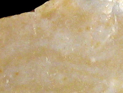
Foto: Jehanne Féblot-Augustins, 2005.
- Les Baraques
- Les Côtes
Sampled sites:
| Material name: | CC2 |
| Synonyms: | Silex Crétacé supérieur Centre - Sénonien. |
| Material (geologic): | Late Cretaceous (Senonian) flint. |

Foto: Jehanne Féblot-Augustins, 2005. |
Sampled sites:
|
| Mode of occurrence: | Irregular blocks and nodules of varying sizes. |
| Cortex: | Worn, thin (max. 1 mm), smooth or pitted with partially rolled patches (material reworked during the Cenozoic), brownish yellow, transition sharp. |
| Colour: | Light brownish grey (10YR 6.5/2), light yellowish brown to light olive brown (10YR 6/2.5 to 10YR 5/4), brown (7.5YR 5/2). |
| Pattern: | Basically featureless, rare pale spots (unreplaced matrix), random specks (skeletal grains). |
| Appearance: | On the whole the material is homogeneous, although some samples show micro-vugs and diaclases; other properties such as lustre (medium to dull), translucency, feel and grain (fine to medium) are highly variable. |
| Structure: | No particular structure. |
| Texture: | Generally wackestone, one sample mudstone. |
| Matrix: | Semi-opaque. |
| Grains: | Generally 20 to 25 %, one sample 5 to 7.5 %; pale, rounded, irregular and highly fragmented (80 to 250 µ), seldom whole with low sphericity (max. 8 mm). |
| Grain composition: | Colonial bryozoans (a majority of bifoliate Cheilostoma, some Cyclostoma), rare thin-walled triaxon sponge spicules, very rare foraminifera; traces of iron oxydes in the samples affected by epigenesis. |
| Further information: | Click here for the original French description (opens in a new window), or here for more information on the attributes used in the description (use your browser's "BACK"-button to return here). |
| Citing: | Information on citing this page can be found here. |
| Locality: | Andert-et-Condon / Andert - Les Baraques |
| Synonyms: | Sampling site Bugey 51 after Féblot-Augustins |
| Geographical description: | N/A |
| Geographical co-ordinates: |
east/x 858,35 north/y 2092 (Lambert zone II, NTF)
This corresponds with |
| Co-ordinate precision: |
The coordinates given were taken from a large-scale map, and are within 50 metres of the actual spot. The latitude/longitude coordinates are a direct transformation of these data on WGS84 and are accurate to the same level, so don't be deceived by the apparently high precision to the single second. The location can be found on the 1:25 000 topographical map sheet 3231 E of the French Institut Géographique National. |
| Geology: |
According to the geological map, the substrate dates to the Oligocene (unit g), but the flint itselfs comes originally from Late Cretaceous (Senonian) strata. Map of all sampled localities of Late Cretaceous flint in the Bugey (PDF, 54 KB, opens in new window). |
| Type of source: | Secondary. |
| Other types of flint: | Apart from the CC2-type of flint, also reworked Early Cretaceous (Valanginian) flint of the Val-type can be found here. |
thumb.jpg) Foto: Jehanne Féblot-Augustins, 2005 |
thumb.jpg) Foto: Jehanne Féblot-Augustins, 2005 |
|
thumb.jpg) Foto: Jehanne Féblot-Augustins, 2005 |
thumb.jpg) Foto: Jehanne Féblot-Augustins, 2005 |
|
 Locality: | Andert-et-Condon / Andert - Les Côtes, France, Ain department |
| Synonyms: | Sampling site Bugey 52 after Féblot-Augustins |
| Geographical description: | N/A |
| Geographical co-ordinates: |
east/x 858,4 north/y 2092,2 (Lambert zone II, NTF)
This corresponds roughly with |
| Co-ordinate precision: |
The coordinates given were taken from a large-scale map, and won't be off by more than 50 metres. The latitude/longitude coordinates are a direct transformation of these data on WGS84 and are accurate to the same level, so give or take an arc-second or two. The location can be found on the 1:25 000 topographical map sheet 3231 E of the French Institut Géographique National. |
| Geology: |
According to the geological map, the substrate is of Oligocene age (unit 'g'). The flint istself originates in Late Cretaceous (Senonian) sediments and lies here in a secondary position. Map of all sampled localities of Late Cretaceous flint in the Bugey (PDF, 54 KB, opens in new window). |
| Type of source: | Secondary. |
| Other types of flint: | Apart from the CC2 flint, quite a lot of other Late Cretaceous (Senonian) flints can be found here, CC3a, CC3b, CC4a, CC4b as well as Early Cretaceous (Urgonian) material of the Ur-type |
thumb.jpg) Foto: Jehanne Féblot-Augustins, 2005 |
| Last modified on: November 15, 2005 |
Contents primarily by: Jehanne Féblot-Augustins |
Comments to: |