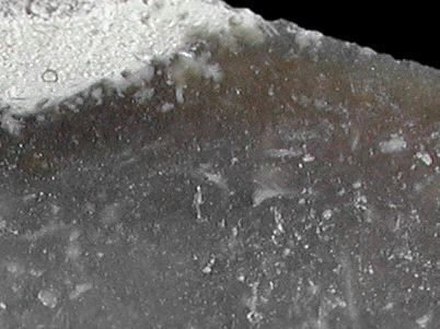
Foto: Matthias Rummer, 2008
- Sangstrup klint
- Fornæs
Sampled sites:
| Material name: | Danian flint |
| Synonyms: | bryozoic Danflint |
| Material (geologic): | Lower Paleocene (Danian, Paleogene) flint |

Foto: Matthias Rummer, 2008 |
Sampled sites:
|
(In part adapted from Glob 1954 and Larsen & Kronborg 1994)
| Geographical setting: | 
Foto: Rengert Elburg, 2003 |
| WhatYouSeeAbove | |
| Material and colour: | 
Foto: Rengert Elburg, 2003 |
| WhatYouSeeAbove | |
| Other information: | N/A |
| Knapping notes: | N/A |
| Archaeological description: | N/A |
| Locality: | Sangstrup klint, Djursland, Eastern Jutland, Århus Amt, Denmark |
| Synonyms: | Danish national geologic locality 38 (Larsen & Kronborg 1994); FlintSource sample 378. |
| Geographical description: | WhereItIs |
| Geographical co-ordinates: |
Lat. 56° 28' 07.5" N Long. 010° 55' 39.6" E (Mapdatum WGS 84) |
| Co-ordinate precision: | The coordinates given were taken at the spot where we organized our sample and did the documentation. They are a bit over-precise, as Sangstrup klint is nearly three kilometres long. |
| Other topographical information: | HowToGetThere |
| Additional information: | 
Foto: Rengert Elburg, 2003 |
| WhatYouSeeAbove | |
| Visitors information: | PlacesToEatAndDrink |
| Sampling information: | N/A |
| Sample description: | N/A |
| Locality: | Fornæs near Grenaa, Djursland, Århus Amt, Denmark |
| Synonyms: | Lille Sandvig; Mining site DK 5, according to the catalogue of the museum in Bochum, 3rd edition (Weisgerber et al. (eds.) 1999). |
| Geographical description: | WhereItIs |
| Geographical co-ordinates: |
Lat. 56° 27' 14" N Long. 010° 57' 02" E (Mapdatum WGS 84) |
| Co-ordinate precision: | The coordinates given were taken off the large scale (1:50 000) digital map "Det levende Danmarkskort" and rounded to the nearest arc-second. |
| Other topographical information: | HowToGetThere |
| Additional information: | 
Foto: Rengert Elburg, 2003 |
| WhatYouSeeAbove | |
| Visitors information: | PlacesToEatAndDrink |
| Sampling information: | N/A |
| Last modified on: January, 2008 |
Contents primarily by: Nobody yet |
Comments to: |